


##teaserTitle##
##teaserText##
##LINK##Funding from the state of Saxony relating to the planned closure of the Freiberg mines between 1903 and 1913 led to comprehensive industrialisation in the region. The Elite Fahrzeugwerk (Elite Automobile Plant), founded in Brand-Erbisdorf in 1913, is a typical example of the new industries that…
The Kahla porcelain factory was established in 1844 and had become one of the most important porcelain manufacturers in Germany by the time of World War I. In 1904, shortly before mining ceased in Freiburg, the company director took the decision to establish a new branch in there. The new factory…
The Frohnauer Hammer Mill includes an iron forge and flood ditch, a small workshop building, and the manor house. The hammer mill was previously a grain mill, whose origins most likely date back to the earliest history of Frohnau village. Following wholesale conversion in 1621, it became a hammer mill where various metals were forged – first silver, then copper, and finally iron. In 1692, the hammer mill burned down; it was rebuilt shortly afterwards. The hammer mill ceased operations in 1904. The hammer mill association, established in 1907, acquired the facility one year later, and it was run as a museum from as early as 1909. The water-powered hammer mill is a quarry stone building with a shingle-covered hipped roof and an L-shaped layout. It is powered by water from the Sehma river, which is directed into a separate watercourse by a weir some 300 metres upriver of the forge.
The former Franciscan monastery was built between 1502 and 1512. The original structure was made up of a completely enclosed area surrounded by four tall buildings and the monastery walls. The main entrance to the monastery church was through the “Schöne Tür” (‘Beautiful Door’), formerly known as the “Goldene Pforte” (‘Golden Gate’). The gardens stretched from the monastery to the town walls and small cloister gate. The monastery was deconsecrated as early as 1539. However, a number of historical works of art, and the monastery’s library, have survived. By 1577, the monastery church was derelict and the “Beautiful Door” was relocated to St. Anne’s Church. Today, the high altar of the monastery church serves as the high altar of St. Catherine’s Church in Buchholz. In the early 19th century, much of the monastery was demolished. All that survives today are wall of the choir with six windows, the remains of the enclosure walls, and some cellar systems.
The Annaberg mining storehouse, built on the site of the former monastery towards the end of the 18th century, is a solid three-storey structure with an attic extension. As a mining storehouse, it was primarily used for grain. However, other items were also stored here. The original vaulting survives in the hallway on the ground floor. Despite extensive remodelling, the characteristic solid stone structure of this former storage building has been retained.
The Schmalzgrube Ironworks is one of the few objects preserved in its original condition from among the once numerous pig-iron processing works in the Erzgebirge. The eight-metre-tall blast furnace was built in 1659 from quarry stone, and the forge manor house was constructed in 1776. Together, they…
Exposed by the extraction of sand, gravel and basalt, Scheibenberg’s imposing basalt columns, which stand up to 30 metres tall, were a reference point in the famous Plutonist/Neptunist controversy of 1800. The dispute between Freiberg scholar Abraham Gottlob Werner (1749–1817) and Scottish geologist…
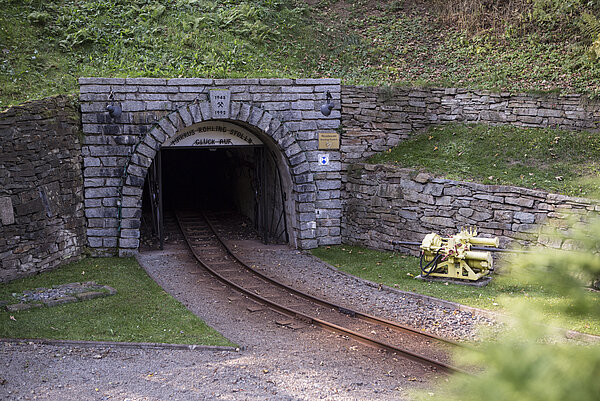
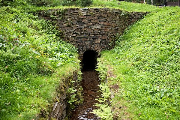
The Aschergraben ditch is one of the prominent, technical masterstrokes from Altenberg’s early mining days. The artificial waterway was created between 1452 and 1458, reliably supplying waterwheels and treatment plants with water for more than 500 years. The name of the trench presumably came from the asher profession. Ashers burned potash in the forests to manufacture suds. Once mining ceased, the water from the Aschergraben was no longer needed, though the trench has been preserved as a functional waterway. It is supplied with water from the transborder forests in the Totes Kind (Cínovecky hřbet) high moor above Böhmisch-Zinnwald (Cínovec). It transported the water 7.4 km, at an incline of 0.3% to 0.6%, from Böhmisch-Zinnwald (Cínovec) to Altenberg. Nearby the Römer shaft the ditch flows into the valley of Tiefenbach creek. Both waters then delivered the stamping mills and ore washers.
For centuries, the building of the town hall which dominates the upper part of Jáchymov has been the seat of the local government of the free royal and mining town. Today it accommodates the town council, the library and an information centre at the ground floor. Historically, the building consists of two parts, the older Schlick (or Alnpeck) house built between 1520 and 1528 and bought by the town council in 1531, and the town hall wing with a massive prismatic tower which was added to the Schlick house during its restoration between 1538 and 1544. The building obtained its current form during a major remodeling between 1901 and 1902 when a storey has been added to the central and the northern wings and the tower was raised. On the ground floor and in the basement of the building, Renaissance vaulted rooms have been preserved.
The administration and assembly building of the mine is a single-storey building, originally built completely as a half-timbered construction, which is slightly bent in the middle and features a high, two-storey mansard roof. Of the part of the building facing away from the shaft, only remains of the timbered framework at the back of the building have been preserved. The gable and the left part of the frontage have been solidly reconstructed. Mansard dormers are set on the front and back of both storeys of the hipped mansard roof. The building features modern turn/tilt windows (segmented into 6 parts) as well as new entrance door.
The stamp mill, which includes an underground stamp wheelhouse, is a two-storey half-timbered structure built between 1816 and 1818. The two-level gabled roof has two rows of dormer windows on each side. On the other side of the stamp mill from the shaft is a small bell tower with a clock mechanism that has survived the years. The stamp mill itself was supplied with energy from the underground stamp wheel by means of rods running up two inclined hading shafts that lead into the mill. The interior layout is essentially as it originally was.
The classicistic Schneeberg town hall with its striking tower structure is a dominating feature on the marketplace. A large sandstone relief dating back to 1911/12 is located over the entrance, which contains a round-arch portal. Above this is set a large coloured cast-iron relief with the Schneeberg municipal coat of arms. Above the coat of arms there is a glockenspiel made of Meissen porcelain on the tower. The town hall is a free-standing, four-wing building with a rectangular courtyard. Inside the town hall, which was fundamentally redesigned in 1911/12, there are painted leaded glass windows containing motifs of Schneeberg and depictions of the various enterprises and trades.
The so-called Fürstenhaus features a magnificent two-storey baroque building, constructed in 1721 on the site of the previous building that had been destroyed in the fire two years earlier. It is relegated to Christian Naumann. The façade was rebuilt after the damage incurred in World War II.
The Trinitatis church completes what is known as the Fürstenplatz (square) in the north-westerly direction. The name of this spital or hospital church refers to the former adjacent hospital founded in about 1500. The St. Trinitatis cemetery, some 3 hectares in size, has always been the principal burial place in Schneeberg. It was established around 1529 directly next to the hospital and expanded in 1701. The Trinitatis hall church, which although partly destroyed in the fire of 1719 was already rebuilt by 1739. The church is a quarry stone structure with a chancel enclosed on three sides and a double tower façade. The towers, built in 1846 in the Historicism style, are equipped with pointed spires. The church structure contains segmental arch windows between the buttresses. The hall in the church features a wooden mirrored vault and single-storey galleries on three sides. The original church furnishings have not been preserved.
The administration and assembly building is the largest of its kind in the Schneeberg mining district. The two-storey structure constructed around 1830 and completely built in the half-timbered style, features a large two-storey hipped gable roof with regularly arranged shed dormers in two rows. The gable on the western side is fully faced with planks.
The mine forge was built in 1839 as an elongated single-storey solid structure with two forges. Since 1947, it has been used as a residential building. Both the gable roof and the pediment sides are faced with shingles. The original mine forge windows (segmented into 16 parts) – including their winter profiles, have been preserved.
The Gesellschaft mine well house, a cistern, was probably installed in the retaining walls of the waste heap during the 19th century. From the outside, the unplastered walls and slate roof of the octagonal well house look similar to a powder house.
The 15 km Floßgraben timber transport ditch has survived almost completely intact. It was built between 1556 and 1559, primarily to supply wood to the Schneeberg and Schlema smelteries. Water from the Zwickauer Mulde river was later used to drive various mills and as raw water. The timber transport…
The Weiße Erde Zeche (which translates as ‘white earth pit’) dates back to the 17th century. Numerous iron ore mines were in operation at this time, meeting demand for raw materials from the hammer mills around Aue, and the Roter St. Andreas mine, where a kaolin deposit had been struck in 1698. In…
The Bergmagazin (mining storehouses) of the Ore Mountains were a particularity in the towns. They provided the miners and their families primarily with foodstuffs. The Bergmagazin of Marienberg was built between 1806 and 1809, as a massive, four-storey quarry stone building with a slate-covered half-hipped roof. The store building was later used both as a storage building for the military and for industrial uses. In the years 2002 to 2006, the historical Bergmagazin was extended (with due attention to its preservation as a monument) into a German-Czech cultural centre. During the comprehensive extension, it was possible to essentially keep the remarkable inner wood construction, but also the cubage of the rooms. Hence the Bergmagazin of Marienberg is the only mining storehouse in the Ore Mountains that have been kept to the greatest possible extent in its original state.
The commissioning of the power plant signalled the end of the old power station, the Lichthaus, which was turned into a residence. The building is closely linked with the construction of the power plant between 1895 and 1905. The introduction of the energy supply system meant that the site and parts of the surrounding area could be supplied with electricity. The single-storey building has a natural stone base, an arched window and a flat gable roof, and is still used as a residence today.
The Smeltery Inn is one of the most prestigious buildings on the site. It was originally the copper hammer manor house, and also served as the shift master’s residence. When a separate house was constructed for the shift master in 1568, it was used as an inn for the workers. The Liquation Works was authorised to sell its own beer. By the 16th century, the Smeltery Inn had become a two-storey building with a solid stonework ground floor, a half-timbered upper floor and a partially extended top floor. Its slate-tiled gable roof, which protrudes slightly, has shed dormers on both side, each with six or seven windows. Above the south-east gable is the copper-plated Baroque bell tower, which has a lantern and a 19th century bell. On the gable directly beneath the bell tower is the splendid dial of the Liquation Works clock, lined with gold leaf.
The assayer’s house is one of the largest and most eye-catching buildings in the Liquation Works. Two storeys high, it comprises a main building and a side building to the north-west. Both buildings have two storeys; each has a gabled roof featuring a range of dormer designs. While the ground floors of the buildings are solid stonework, the upper floors and the gables are half-timbered. When the Assayer’s house and the adjoining copper depository were remodelled, the adjacent building ‒ which has an oriel window and round windows on the ground floor ‒ was erected with older materials from the former copper depository. This was where the refined copper intended for sale was originally stored. The Assayer’s house and the copper depository date back to around 1586.
The workers’ house is a one-storey, solid stonework building with a high hipped roof. The slightly protruding shingle roof features several eyebrow dormers. The gables are clad with boards. The window and door openings are arranged in what is thought to be the original design from the time of the house’s construction. They are picked out with plaster frames. The water ditch that starts at the Long Works open-air museum and that originally flowed into the old refining house reservoir runs between the workers’ house and the assayer’s house to the north-west.
This building is another small, single-storey workers’ house, with a footprint of approximately 80 m². Its structure differs from other workers’ houses, as its gable end faces the works thoroughfare. At the same time, the longer side of the house is parallel to the eastern water ditch, the drainage ditch for the Long Works. Alterations to the house include the addition of new, large windows (in a departure from the original layout), and possibly an asymmetrical entrance. The gable roof, like the gable, is tiled with asbestos shingles and does not have any shed dormers.
This simple building ‒ later modified, converted and extended several times ‒ was erected in 1604 as a residence for the Liquation Works Factor, HIERONYMUS EYMER. Although the building complex was originally set out as a small farmstead, only the main building to the north-east and the adjoining side building have been preserved. The Old Trading Post is today a two-storey, solid stonework building with a basement. It has a gabled roof with shed dormers covered by roofing felt shingle. The older annex mentioned above has a hipped roof. The considerably newer, two-storey annex to the south-east also has a gabled roof; this is not, however, as high as the ridge of the main building. An external flight of stairs on the longer north-eastern side of the building leads to the main entrance on the elevated ground floor. From 1848 to 1886, the building was used as a new school.
South of the large barn is the large, inconspicuous-looking stable building, which is almost 540 m². It has a shallow gabled roof covered in roofing felt. Inside the stable, the structure is supported by cast-iron columns.
To the west of the lower reservoir, right by the upper ditch and close to the upper gate, is an architectural gem: the summerhouse for Liquation Works Factor AUGUST ROTHE. Built from wood and topped with a copper-clad tent roof, the summerhouse has a floor area of around 16 m². The interior is decorated with various verses from the Psalms, and the original colour has been partly restored using local cobalt pigment.
This building now houses the visitor mine museum and the Sauberg Klause café. It was built as a metalworking shop or forge in 1916 and was later used as a storage and administration building. The single-storey building has a row of evenly-spaced windows of two different types on the side facing the street, as well as an entryway fronted by stairs. On the south side of the building is an entrance with a double wooden door surrounded by wood cladding. The building’s hipped roof has four roofed dormers and a shed dormer on the street side.
In the 16th century, the binders industry took on great importance in the Erzgebirge. Its development from its early days through to the 20th century can be traced at the Lengefeld Lime Works. The monument complex is of outstanding importance and provides wide-ranging insights into the history of…
The Grüner Graben ditch, which still carries water today and is largely preserved in its original condition, is one of the most important examples of silver and tin mining infrastructure in the Pobershau area. It exemplifies the water management systems in the Marienberg mining district. Built in…
In the later 18th century, the Seiffen area shifted from mining to woodworking. Today, Seiffen is known for its traditional wooden toys, produced using a special form of wood turning, known as Reifendrehen. This was the only place where the process was perfected for commercial purposes. So it will…
One of the best-preserved paper mills and cardboard factories in Germany, Niederzwönitz Paper Mill illustrates how paper production was a supplier of the mining industry. In 1568, with the expansion of mining administration and the resulting written correspondence, the mill started producing paper…
Wismut’s imposing head office in Chemnitz was built in 1954 as part of the conversion of the Soviet corporation Wismut to a Soviet-German corporation (SDAG). The two monumental neoclassical main buildings played a vital role in the centre. The building at 50 Jagdschänkenstraße is the Head Office of…
The Erlabrunn miners’ hospital is an example of the social facilities that were established in connection with uranium-ore mining in the western Erzgebirge. The first new hospital was built in the GDR and opened in May 1951, its size is illustrative of the intensity of uranium-ore mining after World…
Schwarzenberg Castle was what first drew settlers to the region and was the starting point for the town’s development. First mentioned in historical records in 1212 and converted into a hunting lodge between 1555 and 1558, it remains an emblematic feature of the townscape today. It was once the seat…